


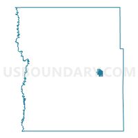
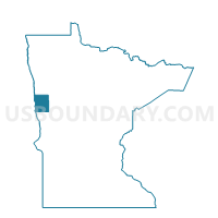
Hawley Voting District, Clay County, Minnesota
About
Outline

Summary
| Unique Area Identifier | 601510 |
| Name | Hawley Voting District |
| County | Clay County |
| State | Minnesota |
| Area (square miles) | 2.53 |
| Land Area (square miles) | 2.53 |
| Water Area (square miles) | 0.00 |
| % of Land Area | 99.84 |
| % of Water Area | 0.16 |
| Latitude of the Internal Point | 46.87599850 |
| Longtitude of the Internal Point | -96.31723600 |
Maps

Graphs
Select a template below for downloading or customizing gragh for Hawley Voting District, Clay County, Minnesota


Neighbors
Neighoring Voting District (by Name) Neighboring Voting District on the Map
- Cromwell Twp. Voting District, Clay County, MN
- Eglon Twp. Voting District, Clay County, MN
- Hawley Twp. Voting District, Clay County, MN
Top 10 Neighboring County Subdivision (by Population) Neighboring County Subdivision on the Map
- Hawley city, Clay County, MN (2,067)
- Eglon township, Clay County, MN (508)
- Hawley township, Clay County, MN (474)
- Cromwell township, Clay County, MN (345)